Overlayr by MapMagician
Overlay any image, site plan, or scanned map on Google satellite imagery in seconds. Place control points, georeference with desktop-grade precision, measure area and distance, and export KMZ for Google Earth — all from your Android phone.
Every surveyor, valuer, and planner has faced the same problem: you have a map — a scanned survey sheet, a PDF layout plan, a development plan extract — and you need to know exactly where it sits on the ground. Desktop GIS software like QGIS or ArcGIS can georeference it, but it's workstation-bound, slow to learn, and useless when you're standing in the field.
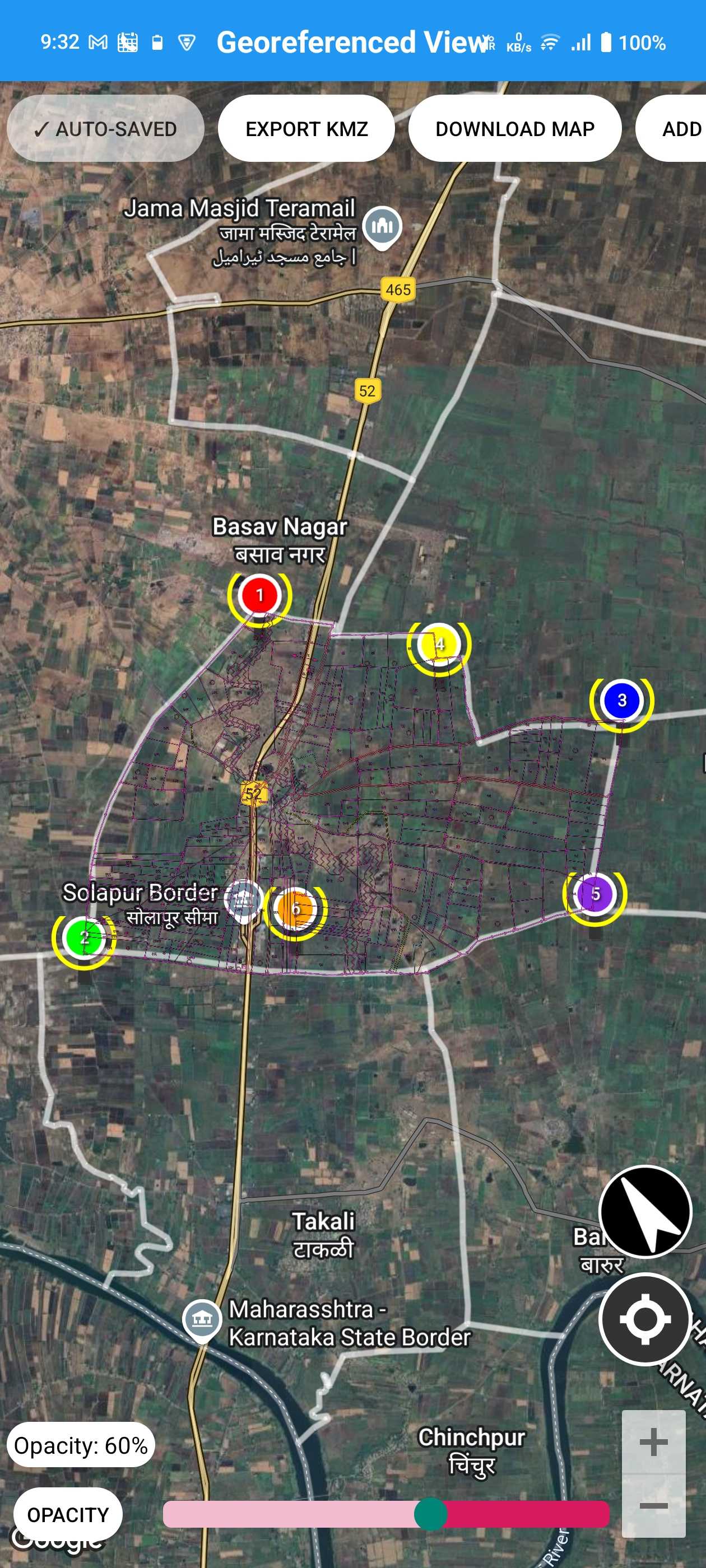
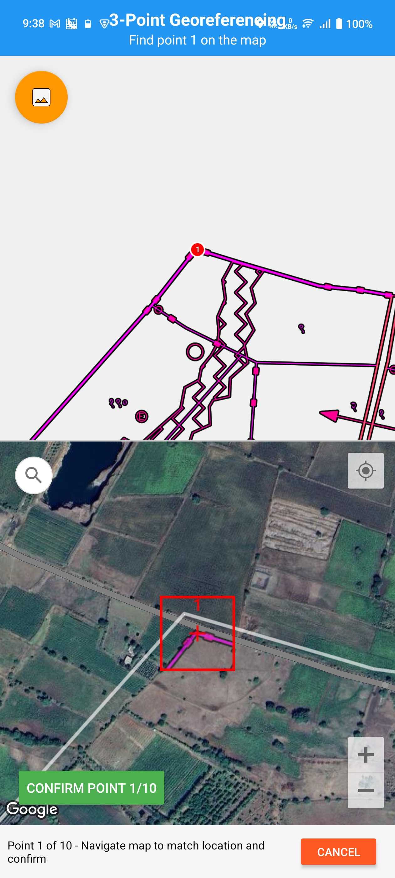
Overlayr solves this on your phone. Import the image, tap at least three control points — matching recognizable features on your map to the same spots on Google satellite imagery — and Overlayr warps the image to fit its true position. Slide the transparency control to compare your plan against the ground below, measure any area or distance, and walk the site with GPS showing where you stand on the overlaid plan.
When you're done, export the georeferenced overlay as KMZ for Google Earth, as an ArcGIS-compatible world file, or as a point ZIP package — formats QGIS, ArcGIS, and any standard GIS software read directly. What used to need a desktop workstation is now a two-minute job on Android — free to download, with offline support for field work.
Professional georeferencing with precision control points


Load any JPG, PNG, or PDF — a scanned paper map, survey sheet, layout plan, or development plan extract. Large high-resolution files are supported.
Match points on your image to the same spots on Google satellite imagery. Magnified precision views help you tap exactly on road junctions, plot corners, or buildings.
Overlayr warps the image live to fit its true position. Slide the transparency control to compare your plan against the ground and fine-tune alignment.
Measure area (m², hectares, acres) and distance directly on the overlay, then export as KMZ for Google Earth, ArcGIS world file, or point ZIP for GIS software — or share a high-res screenshot.
Precision control points with magnified views, live overlay transformation, drag & drop accuracy, and transparency controls for seamless blending
High-res satellite imagery, smart location search, GPS integration for auto-location, and custom markers with labels and details
Area calculation in m², hectares, acres, distance measurement tools, live calculations with instant feedback, metric and imperial support
Export as KMZ for Google Earth, ArcGIS-compatible world file, or point ZIP package for GIS software — plus high-res screenshots and easy sharing via email and cloud apps
Supports JPG, PNG, PDF formats, high-resolution image handling, offline capability, memory optimized for large files
Unlimited projects with Premium, auto-save protection, organized project library, instant loading and resuming
Create a survey overlay in minutes — overlay survey maps and sheets on satellite imagery with precision control points for accurate field verification and boundary marking
Visualize development plans on live maps, assess zoning changes, and present proposals with professional overlays
Mark property boundaries and zoning plans, create professional presentations for clients with accurate overlays
Map field areas, habitats, and ecological zones. Document environmental changes with georeferenced overlays
Overlay site layouts and building plans on location for better project planning and coordination
Visualize evacuation routes and response zones, plan emergency services deployment with georeferenced maps
Overlay a scanned trail map, forest map, or trek route on satellite imagery and follow your live GPS position on it — works offline in remote areas once loaded. Hiking map overlay guide →
In India, Overlayr is widely used to georeference survey maps, gaon nakasha sheets, layout plans, and development plan extracts against current satellite imagery — so you can see exactly how an official plan lands on the ground. Pair it with our free Development Plan GIS viewer, which already covers 157+ Indian regions with georeferenced DP maps — or browse development plan maps district-by-district on dpplans.com.
On desktop, georeferencing means the QGIS Georeferencer or the ArcGIS georeferencing tools: load the raster, place ground control points, pick a transformation, export. Powerful — but tied to a workstation and a real learning curve. If what you actually need is to see where a plan sits on the ground and share it, Overlayr runs that same control-point workflow on your Android phone, standing on the site.
Searching for "QGIS mobile" or "ArcGIS mobile"? QGIS itself doesn't run on Android — its companion apps (like QField) focus on field data collection, and Esri's ArcGIS Field Maps does the same on the Esri side. Neither georeferences an image on the phone. That gap — mobile georeferencing of scanned maps, site plans, and PDFs — is exactly what Overlayr is built for.
To be clear: Overlayr is not a full GIS and doesn't try to be. It's the georeferencing-and-overlay step made mobile — and because it exports standard KMZ, ArcGIS-compatible world files, and point ZIP packages, the result flows straight back into Google Earth, QGIS, or ArcGIS when you do need desktop analysis.
| Overlayr (Android) | QGIS Georeferencer (desktop) | ArcGIS (desktop) | |
|---|---|---|---|
| Platform | Android phone / tablet | Windows / Mac / Linux | Windows |
| Price | Free (optional Premium) | Free, open source | Paid licence |
| Learning curve | Minutes — 3 taps to a fitted overlay | Steep (GIS concepts, CRS, transformations) | Steep (GIS concepts, CRS, transformations) |
| Georeference an image | 3+ control points on live satellite imagery | GCPs + transformation settings | GCPs + transformation settings |
| Live GPS on the overlay in the field | Yes — walk the plot on your plan | No | Separate mobile apps required |
| Measure area & distance | Built in (m², ha, acres) | Yes | Yes |
| Export formats | KMZ · ArcGIS world file · point ZIP | GeoTIFF and other rasters | GeoTIFF and other rasters |
| Best for | Field georeferencing, overlay checks, quick sharing | Full desktop GIS analysis | Enterprise GIS workflows |
Desktop GIS tools like QGIS and ArcGIS are powerful, but georeferencing a single map means transferring files, opening a project, and working through dialogs. Overlayr does the same alignment in about two minutes, on the device that's already in your pocket.
The overlay isn't just for the office — stand on the plot and see your live GPS position on top of the georeferenced plan. No desktop workflow can do that during a site visit.
Overlayr complements desktop GIS rather than replacing it: the KMZ you export opens in Google Earth and imports cleanly into QGIS, so field-georeferenced maps flow straight into your existing workflow.
A map overlay is an image — a site plan, drawing, scanned sheet, or another map — placed on top of a base map so you see both together. In GIS, creating an overlay means georeferencing the image: aligning it to real-world coordinates so it sits at its true position and scale. Overlayr does exactly this on Android, overlaying your image on Google satellite imagery with adjustable transparency.
Install Overlayr from Google Play, import your image (JPG, PNG, or PDF), and place at least 3 control points — matching a point on your image to the same spot on the satellite map. Overlayr then warps the image so it sits correctly on Google satellite imagery. A transparency slider lets you check the alignment against the ground below.
Yes. Scanned paper maps, old survey sheets, layout plans, and PDF drawings are exactly what Overlayr is built for. Scan or photograph the map, import it, and georeference it with control points — the app handles high-resolution files and is memory-optimized for large scans.
Accuracy depends mainly on how carefully you place control points, not on the device. Overlayr provides magnified precision views while placing each point and live overlay transformation, so with 3 or more well-chosen points on recognizable features you can achieve desktop-grade alignment on satellite imagery.
After georeferencing, choose your export: KMZ opens directly in Google Earth (desktop and Pro) with your image at its true coordinates; an ArcGIS-compatible world file lets ArcGIS and QGIS load the georeferenced image natively; and a point ZIP package carries the image with its georeferencing data for GIS workflows. You can also export high-resolution screenshots for reports.
Yes — Overlayr has offline capability, so you can keep working with your imported images and saved projects in the field. Fresh satellite imagery requires a connection when first loading an area.
Overlayr is free to download and use from Google Play. Premium (an optional in-app purchase) unlocks unlimited saved projects for professionals who work on many sites.
JPG, PNG, and PDF. High-resolution images are supported and the app is optimized to stay responsive with large files, so detailed scans of survey sheets and development plans work well.
They solve different problems. Map Over Pro is an older app built mainly for viewing a custom map overlay while hiking or navigating in remote areas, aligned with two matched points. Overlayr is built for professional georeferencing: 3 or more control points with live warping for an accurate fit, area and distance measurement, and GIS-grade exports — KMZ for Google Earth, an ArcGIS-compatible world file, and a point ZIP package that desktop GIS software reads directly. Overlayr is free to download. And it covers the hiking use case too — georeference a trail or forest map once, then follow your live GPS position on the overlay offline in remote areas.
Not the desktop applications themselves. QGIS has mobile companions like QField and ArcGIS has Field Maps, but those are built for field data collection — neither lets you georeference an image on the phone. For mobile georeferencing — fitting a scanned map, site plan, or PDF onto satellite imagery — Overlayr covers that workflow on Android and exports KMZ that both QGIS and ArcGIS can import.
For the georeferencing-and-overlay workflow, yes — Overlayr is a free mobile alternative to the QGIS Georeferencer and the ArcGIS georeferencing tools. You place control points on Google satellite imagery just like desktop GCPs and get a fitted overlay in minutes on your phone. For full spatial analysis (buffers, joins, styling, projections), a desktop GIS is still the right tool.
It replaces the desktop trip for field georeferencing — not the whole GIS. Use Overlayr on-site to georeference plans and check them against the ground, then export KMZ; the file imports directly into Google Earth, QGIS, or ArcGIS whenever you need deeper analysis. Many users pair Overlayr with desktop GIS exactly this way.
Use Overlayr when you already have a map or plan (a scanned sheet, PDF drawing, or image) and want to position it on satellite imagery — georeferencing. Use Location Plan Maker Pro when you want to create a new location plan or site map from scratch, with landmark markers, roads, and a branded PDF export.
Free map overlay tool & mobile georeferencing app for surveyors, valuers, planners, and GIS experts